A passage plan is a written plan for getting your boat from one place to another safely, and the part people forget is the last bit: what will we do when it does not go to plan? Anyone can draw a line between two ports. The plan is everything around the line: the weather window, the fuel, the way in, the way out, who is aboard and who ashore knows where you are. It works the same off the Gold Coast, across the Tasman or in the Mediterranean; only the details change.
Key facts
- What it is — a written plan for the whole trip, berth to berth, with alternatives
- The 4 steps — appraisal, planning, execution, monitoring (IMO Resolution A.893(21))
- The rule — SOLAS V/34 requires voyage planning; how it applies to a private yacht depends on your flag
- The test — a plan is only good if it tells you what to do when conditions change
- Our offer — we review the plan you have, or write it for you
What is passage planning, and is it the same as voyage planning?
Passage planning is the job of working out, before you leave, how the trip will be done safely. SOLAS Chapter V, Regulation 34 calls it voyage planning and says the master must plan the intended voyage on appropriate charts and publications before going to sea. Port State Control guidance describes the result as a berth-to-berth plan. Yachting courses and clubs usually say passage planning. In practice they are the same job: a plan for the whole trip, from the moment you leave the berth to the moment you are alongside at the other end.
Whether the law requires one for a private yacht depends on the flag and where you are, so check yours. The reason to do it anyway is simpler. A plan made calmly on the dock is better than decisions made tired, offshore, with a deadline.
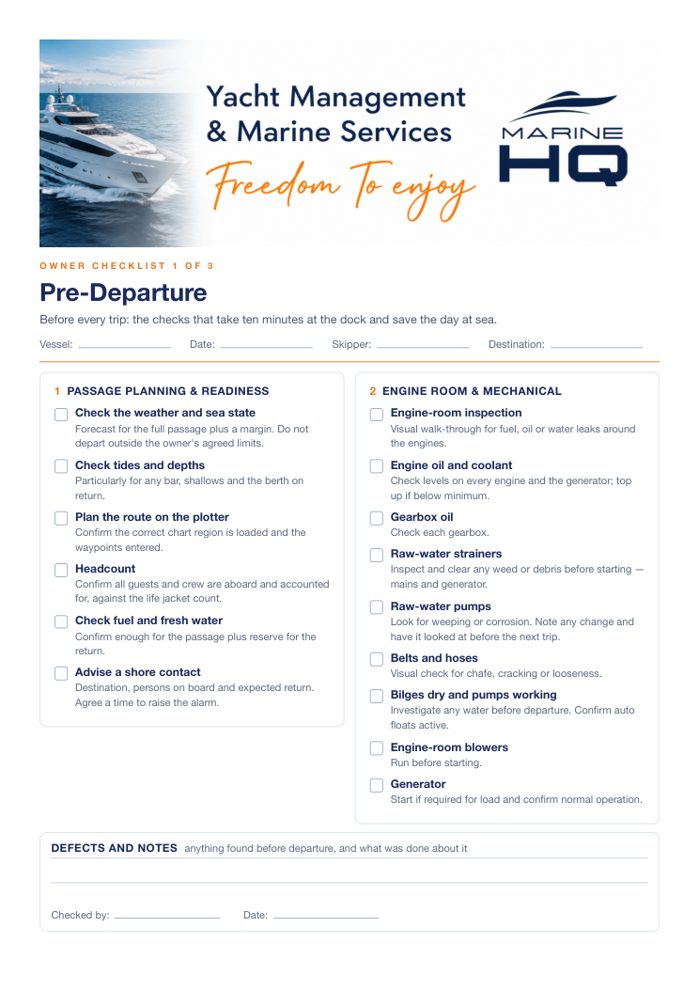 From The Yacht Owner's KitOwner Checklists: Pre-Departure, Stand Down, Wash-Down
The 4 stages of passage planning
The IMO’s guidelines for voyage planning, Resolution A.893(21), break the job into four parts. Use them as the spine of your own plan, however big the boat.
- Appraisal. Gather everything: charts, pilot books, weather patterns for the season, port and entry information, the boat's limits, the crew's experience.
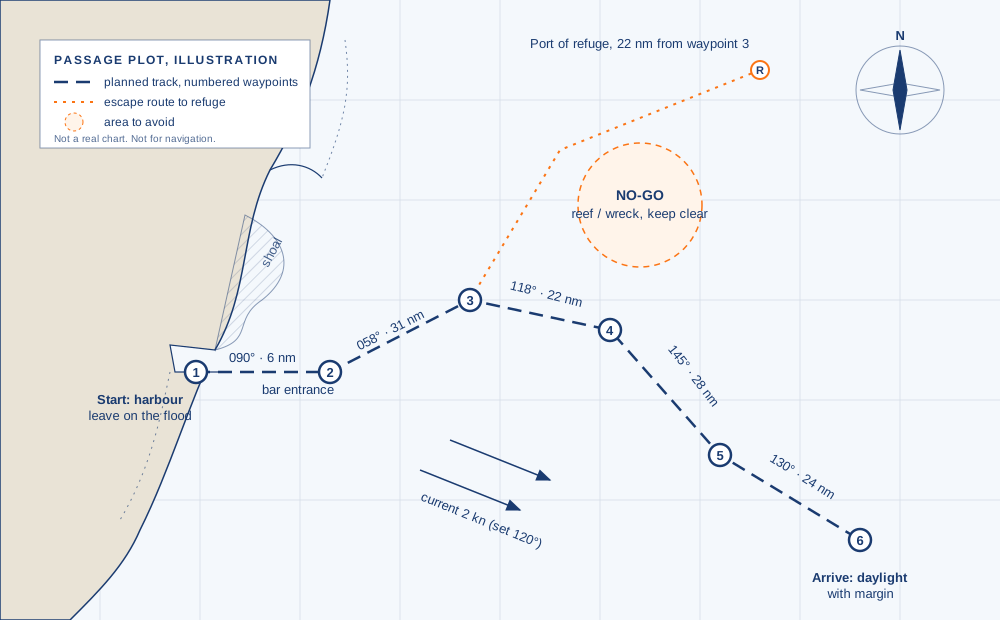
- Planning. Draw the route and the alternatives. Work out distances, speeds, fuel, tides, daylight arrivals and ports of refuge.
- Execution. Brief the crew, check the latest weather, confirm the boat is ready, and leave on the plan, not on the day you hoped for.
- Monitoring. Check position, fuel and weather against the plan every watch, and change the plan early when they drift apart.
How to make a passage plan, step by step
Twelve things to settle before you leave any port. This is the appraisal and planning stages in the order we work through them.
1. The season
The same route can be easy in one month and dangerous in the next. Every ocean basin has its own tropical cyclone season, monsoon and swell pattern. Find out the season for each leg, not just the departure port, and plan to be somewhere safe when the bad months start. The US National Hurricane Center’s Mariner’s Guide has a chapter on tropical cyclone seasons by basin that is a good place to begin.
2. The weather window
Pick the window from the forecast, not the calendar. Look at wind, swell height and period, and above all wind against current or against swell, which turns a modest sea steep and short. Decide your go and no-go limits for this boat and this crew before the pressure of a departure date is on you. Re-check right up to the lines coming off.
3. Your boat’s real range
Brochure range is not passage range. Work out fuel from your own burn at your planned speed, then add a reserve. Rough weather, a dirty hull, a head current or a forced diversion all cost fuel. Know the longest leg between fuel, and whether you can reach a port of refuge from the middle of it. Our fuel cost guide shows how burn changes with speed.
4. Entrances and arrival times
Many harbours are easy in daylight and on the right tide and hazardous in the dark or on the ebb. Check every entrance for bar conditions, depth at low water, tidal streams, restrictions and the hours you can enter. Plan to arrive in daylight with margin. A late arrival that forces a night entrance into a strange harbour is the plan failing, not bad luck.
5. Ports of refuge
For each leg, list where you can duck in if the weather turns or something breaks, and how far away that is at the middle and the far end of the leg. If the answer is “nowhere for 200 miles”, that is a decision to make deliberately, with extra fuel and spares, not a surprise.
6. Charts, pilots and paper backup
Carry up-to-date electronic and paper charts for the whole route, plus the pilot books or sailing directions. Electronic charts fail, and remote regions often have poor or old survey data. Treat unsurveyed or old-survey areas with extra margin, and keep a paper plot of your route.
7. Entry, exit and paperwork
Every country has its own rules for arrival: clearance, customs, immigration, biosecurity, cruising permits and agents. Some require notice before you arrive, and some ports of entry are far apart. Start this early. Flag, registration, crew passports and visas, insurance certificates and the boat’s papers all need to be current and on board.
8. Crew, watches and rest
Count the people, the qualifications and the rest. A passage plan should say who keeps which watch, who is the second person who can run the boat, and when the skipper actually sleeps. Tired crews make the mistakes that end passages. Cowes Harbour’s passage-planning notice lists the condition of the crew alongside weather and tide as something to plan for.
9. Safety gear and drills
Lifejackets, liferaft, EPIRB or PLB, flares, fire gear, bilge pumps, medical kit and spares are all checked against the length and remoteness of the trip, not a minimum. Brief the crew on where things are and who does what in a man-overboard, a fire and a flooding. Insurers often care about all of it.
10. Communications and shore contact
Have more than one way to talk and get weather offshore: VHF, satellite voice or messaging, and a backup. Leave a written plan with someone ashore: route, dates, boat and crew details, check-in times and what to do if you miss one. AMSA’s guidance for boaters starts with exactly this: plan your trip and tell someone where you are going.
11. Boat readiness
Before a long passage the boat itself needs checking: engines and fluids, filters, generator, steering, stabilisers, batteries, bilges, anchors, and the hull and running gear. A pre-departure service and a short sea trial find problems at the dock, where they are cheap, rather than offshore, where they are not.
12. The alternative plan
Write down what you will do if the weather window shuts, if a mechanical fault appears, if someone is injured or if a port is closed to you. Include who to call and the decision points where you will turn back or divert. This page of the plan is the one you hope never to use and are glad to have.
Worth knowing
Planning is not a one-off document. The monitoring stage means comparing position, fuel and weather with the plan every watch and updating it when they diverge. The best plans on paper are the ones that get changed early.
Passage plan template
Copy these headings into a document or a notebook. One row per leg, plus the whole-trip items at the bottom.
| Item | What to write |
|---|---|
| Boat | Name, flag, length, draft, air draft, fuel capacity, cruising speed and burn |
| Crew | Names, roles, qualifications, watch roster, emergency contacts |
| Route | Departure port, each waypoint, arrival port, total distance |
| Each leg | Distance, planned speed, time, tides and currents, daylight or dark arrival |
| Entrances | Bar, depth at low water, tide window, restrictions, VHF channel |
| Weather | Forecast sources, go limits, no-go limits, date and time checked |
| Fuel | Burn per hour, fuel per leg, reserve, where you can refuel |
| Refuge | Ports of refuge for each leg, and the distance to each |
| Paperwork | Clearance, permits, agents, certificates, insurance |
| Communications | Radio, satellite, check-in times, who is ashore and their number |
| If it goes wrong | Decision points, diversion options, who to call |
Passage plan example: Gold Coast to Sydney
- 1Gold Coast Seaway Departure · cross on the flood
- 3Coffs Harbour No bar · 143 berths
- 6Port Stephens (Nelson Bay) All-weather · fuel 24/7
- 7Newcastle All-weather · published fuel and berth rates
- 8Pittwater (Broken Bay) 16 nm north of Sydney Heads
- 9Sydney Harbour Rushcutters Bay
This is a short worked example in the same headings. The figures come from our Gold Coast to Sydney guide, which has the sources.
| Item | Example entry |
|---|---|
| Route | Gold Coast Seaway to Sydney Harbour, about 470 nautical miles |
| Legs | Seaway to Coffs Harbour (about 150 nm), Coffs to Port Stephens (about 160 nm, the longest), Port Stephens to Sydney (85 to 110 nm) |
| Entrances | Sydney, Newcastle and Port Stephens have no bar. Ballina, Yamba, Port Macquarie, Camden Haven, Forster and Swansea are designated bars: incoming tide only, lifejackets on |
| Weather | Avoid southerly changes against the south-setting East Australian Current; leave the Seaway at first light on the flood |
| Fuel | Plan Coffs as an overnight stop, not a fuel stop; top up at Newcastle or Port Stephens |
| Refuge | Yamba and Forster in reserve to shorten a leg |
| Shore contact | Log on with Marine Rescue NSW by VHF 16, with destination, people aboard and expected arrival |
Passage planning apps and software
Charts and weather now live in apps and on the chartplotter, which makes plans easier to draw. They do not make them for you. An app will draw the line and add up the distance. It will not tell you whether the entrance is safe on the ebb, whether your crew is rested, or where you go if the fuel computes short. Use the tools for the arithmetic and keep the judgement on paper.
What we do
A lot of owners and captains have a plan in their head and a route on the chartplotter, and want someone experienced to look at it before the lines come off. That is what we do.
- Passage plan review. You send us your route, dates, boat details and crew. We go through it line by line and tell you what is missing, what is risky and what we would change. A second pair of eyes before a long crossing.
- Passage plan build. We write the full plan for you: route and alternatives, weather windows, fuel and range, ports of refuge, entry paperwork, crew and watch plan, and emergency procedures.
- Support while you are under way. Weather routing and shore support for an owner or captain making the crossing themselves, or our own delivery crew aboard to take her there.
We plan and support passages from the Gold Coast, Sydney and the Whitsundays, and further afield across the Pacific. The fee depends on the passage and how much of the work you want, so we quote each one. Call 0439 748 387 or email yachtsupport@marinehq.com.au with your route and dates.